")
")
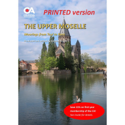
This guide covers the 394kms of the river from Neuves-Maisons in France through Luxembourg and Germany (where it is known as the Mosel) to finally join the Rhine at Koblenz. It includes step-by-step navigation details for the river, including distances; bridge heights; lock dimensions and VHF channels; descriptions of moorings and facilities, and information on the sights, culture and visitor attractions along the route.
This guide covers the 394kms of the river from Neuves-Maisons in France through Luxembourg and Germany (where it is known as the Mosel) to finally join the Rhine at Koblenz. It includes step-by-step navigation details for the river, including distances; bridge heights; lock dimensions and VHF channels; descriptions of moorings and facilities, and information on the sights, culture and visitor attractions along the route.
It is a 50-page A4 guide, written by CA members Andy and Gwen Mulholland, who have cruised extensively over the past decade in France, Belgium, Germany and the Netherlands, and edited by Gordon Knight.
The guide is regularly updated (usually annually) using reports submitted by members of the CA's European Inland Waterways Section (EIWS).
Note that this is the printed version of the guide which is free for CA members to download. The digital version of the guide can be downloaded free for members here.
Data sheet
This guide covers the 394kms of the river from Neuves-Maisons in France through Luxembourg and Germany (where it is known as the Mosel) to finally join the Rhine at Koblenz. It includes step-by-step navigation details for the river, including distances; bridge heights; lock dimensions and VHF channels; descriptions of moorings and facilities, and information on the sights, culture and visitor attractions along the route.